
Uncategorized
Review Land Use Plans in Your Area
Link to Review draft elements of Plan2040
The online tool will allow you to access documents that help guide this draft plan, but the three most important things are three tabs that allow you to visually see what is happening:
1. Development Policy Area Maps – of particular interest on the Broadneck is what is categorized as a “Peninsula” – very important for transit and development decision. Does you neighborhood have adequate transit access that precludes a “Peninsula” designation, even when you feel trapped on Summer weekends?
See how your area is being categorized.
Overlay Areas
Transit-Oriented
Village Center
City of Annapolis
Development Policy Areas
Rural and Agricultural
Peninsula
Neighborhood Preservation
Corridor Management
Critical Economic
Town Center
Link here to comment of Development Policy Areas:
2. Planned Land Use Map – Use a slider to see new use designated on the left as compared to the old 2009 Use designations on the right. Are you in for a surprise in your area?
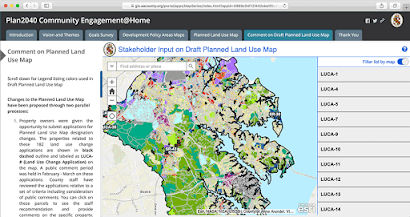
3. Comment on Draft Planned Land Use Map – see exactly what and where land owners and County planners have aske for a change in land use designations. Will the woods next to you turn into a commercial district? Here you can input comments for or against proposed changes (click the links on the right and submit a comment), and see what County staff recommendations on these requests are, as well as other comments by visitors like you.
This is a very useful tool, easy to use, and allows you to quickly review the situation in your area. We highly encourage you to click the link and check it out.
If you would like some guidance, the County has recorded a guided tour of the site which you can access here:
Webinar on Regional Areas 4, 5, and 6
Click here to view a briefer tutorial on how to use the interactive website.
Click here to see the slides from the presentation.